Using Esri’s Image Classification Wizard
Included in this tutorial:
Accessing the Image Classification Wizard
Reviewing the Steps of Image Classification
Executing the steps (required and optional) of image classification with an example for demonstration
Software version in examples: ArcGIS Pro 3.0.2
Tutorial Data: This tutorial demonstrates with Landsat 8 data downloaded from the USGS EarthExplorer. The dataset is a scene acquired in late 2018, covering Phnom Penh, Cambodia.
US Geological Survey. “Scene LC80_L1TP_126052_20181225_20190129_01_T1” [geoTIFFs]. Landsat 8 OLI/TIRS, Collection 1, Level 1. Acquisition date: 25 December 2018. (29 January 2019). Accessed 14 August 2020 from https://earthexplorer.usgs.gov/
Credits: L. Meisterlin (2022)
This tutorial demonstrates the processes of supervised image classification in ArcGIS Pro using the software’s built-in wizard and a classification schema and training samples created in the Creating Training Samples for Supervised Image Classification tutorial.
Related tutorials:
This tool requires either the Image Analyst Extension in ArcGIS Pro. To verify that you have the Network Analyst Extension, see Which Esri Extensions Is My Software Licensed to Use?
For guidance on downloading Landsat data from the EarthExporer website, see Downloading Landsat Data from the USGS EarthExplorer.
Again, this tutorial begins with training samples created in the Creating Training Samples for Supervised Image Classification tutorial.
Accessing the Classification Wizard
To access the Classification Wizard, click through (on the main menu ribbon) Imagery > Classification Wizard (you must have an appropriate raster layer highlighted in the Contents panel for these options to be present).
summoning the Classification Wizard
The steps of Image Classification
The “wizard” will walk you through the many steps (and many options) of the image classification process. This tutorial will demonstrate one process with a few standard options (and those needed for the relevant workbook exercises). Note: if you choose different options in the initial “configuration” step of the process, then the remaining steps will be different than those outlined below.
MORE: For more information about the Image Classification in ArcGIS Pro, see Esri’s guide to the wizard here.
Step 1: Configuring your image classification
In the first panel, specify the Classification Method and Type. Here you will also specify the Classification schema and the Output Location for all output layers and files produced through this wizard.
Optional settings include adding a pre-made segmented image, training samples (which you can also edit later), and a reference dataset.
Step 1: the Configure panel
In the screenshot above, we…
chose a Supervised classification method, because we are including training samples that we have created to govern the classification process
specified an Object-based classification type, which is based on localized groupings of cell values (rather than determined on a cell-by-cell, “pixel-by-pixel,” basis) and will include creating a segmented layer
added our classification schema file
added our training samples feature class
Step 2: Segmentation
The segmentation process is required for an object-based classification. Here you can specify and adjust how cell values are grouped into segments across the image. Clicking the “Preview” button at the bottom of the segmentation panel will produce a new layer in your map project called “Preview_Segmented” which changes with the settings as you make adjustments. With these, you can control the level of aggregation or generalization that will be used in classifying your image.
Step 2: the Segmentation panel
Note: With the “Previous” and “Next” controls of the wizard, you can return to this panel if you are unsatisfied with the outcome of the classification and decide different segmentation parameters are required.
Step 3: the Training Samples Manager (again)
In the third step, you will see the training samples you loaded in the initial “Configure” panel. Here you can edit, add, or otherwise modify training samples. For a demonstration of using the Training Samples Manager see Creating Training Samples for Supervised Image Classification.
Step 3: the Training Samples Manager
Note: With the “Previous” and “Next” controls of the wizard, you can return to this panel if you are unsatisfied with the outcome of the classification and decide more training samples (or different training samples) are required.
Step 4: Train!
In the fourth step, you will use the training samples and segmentation to train the classifier (i.e., to train the software to classify the values in your image). The result is a preview of the eventual classification, which is added to the map project.
Note that you can run more than one classification type during this step, previewing the outcome of each. Notice also that you can toggle several different segment attribute options to further specify the segmentation process.
The demonstration below shows the different classifier options, and runs both the Support Vector Machine option and the Maximum Likelihood option.
Step 4: Train
There are two layers added to the map project resulting from the Train step:
A segmented layer (no longer called “preview”)
A preview of the classification (which we finalize in the next step).
Examining our classification preview: There are two observations worth noting from the demonstrated example.
First, the Support Vector Machine classifier produces better results than the Maximum Likelihood classifier in this case.
Second, we can see quite readily that our “water” areas are properly classified by the Support Vector Machine classifier, but our two-class schema is insufficient for describing the variations in the study area. (Built-up urban areas are classified within our vegetation class. In effect, this class could be more appropriately relabeled “not water” within our example schema.)
Step 5: Classify!
In the fifth step, we apply the classifier produced in the training to our image to output the classified raster dataset. The options for the Classify panel include
Specifying the name of the output classified dataset which will be saved in the output location specified in the initial configuration step
Choosing which classifier to use, if (as in our demonstration) you trained more than one classifier in the previous step. In our demonstration, we choose the classifier trained using the Support Vector Machine option (labeled with “SVM” in its default name)
Optional outputs (which will also be saved in your output location) include the classifier delineation file and the segmented image, either of which you may want to use later.
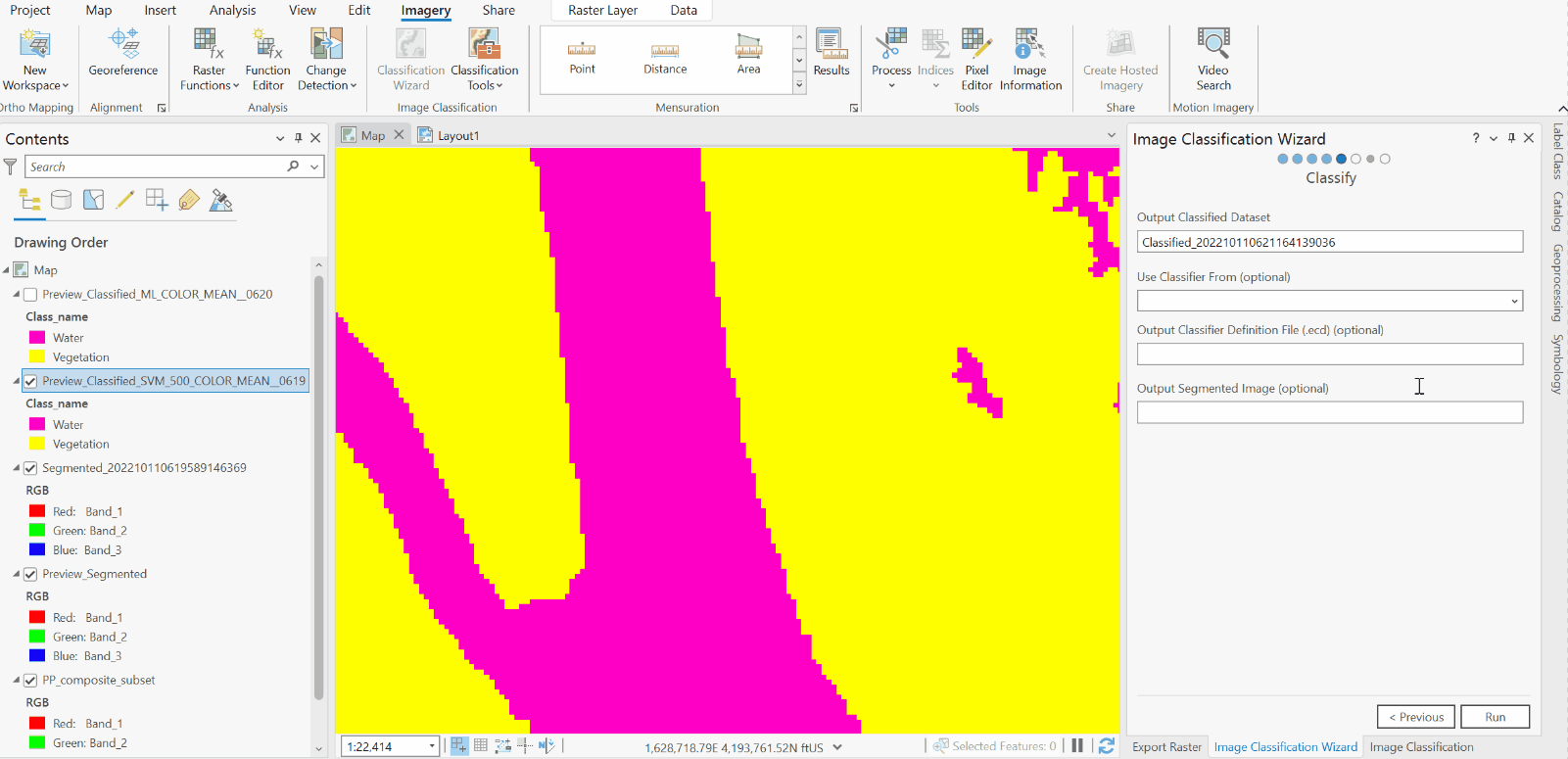
Step 5: Classify
After this step, you’ve officially classified (and saved the classified image) raster.
Steps 6 & 7: Edits and Changes (optional)
Step 6: Merging Classes
If you need to, you can use the options in the Merge Classes panel to do as its name suggests: merge multiple classes together in your results.
Step 6: Merge Classes
Step 7: Manually changing specific classification results
Lastly, the Reclassifier panel gives you the option to manually change the class assigned to either specific objects (for object-based classification methods) or specific regions.
Important Note: Despite the name of this panel, this is not the equivalent of raster value reclassification, which is described in the Reclassifying Rasters tutorial.
To do this, you would first use the tools listed under “Edit type” (which work as interactive selection tools) to choose the objects or areas to reassign, and then specify their reassigned class under “Remap Classes.”
Step 7: Reclassifier